 Catalogue PIGMA
Oceanographic geographical features
Type of resources
Available actions
Topics
Keywords
Contact for the resource
Provided by
Years
Formats
Representation types
Update frequencies
status
Scale
Resolution
-
Sediment Profile Images (SPIs) are commonly used to map physical, biological and chemical/nutrient gradients in benthic habitats. SpiArcBase is a software that has been developed for the analysis of Sediment Profile Images (SPIs). It has been conceived to improve the objectivity of extracted information (especially the apparent Redox Potential Discontinuity (aRPD). The software presents a graphical user interface designed to enhance the interpretation of features observed on SPIs in an objective manner and to facilitate image management and structures visualization via a data base.The software also allows for the storage of generated data and the automatic computation of a benthic habitat quality index. The facilities provided within JERICONext include access to the software through free downloading and assistance in its utilization.
-
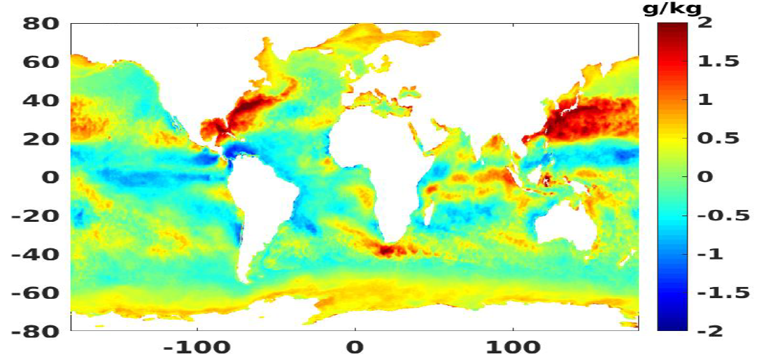
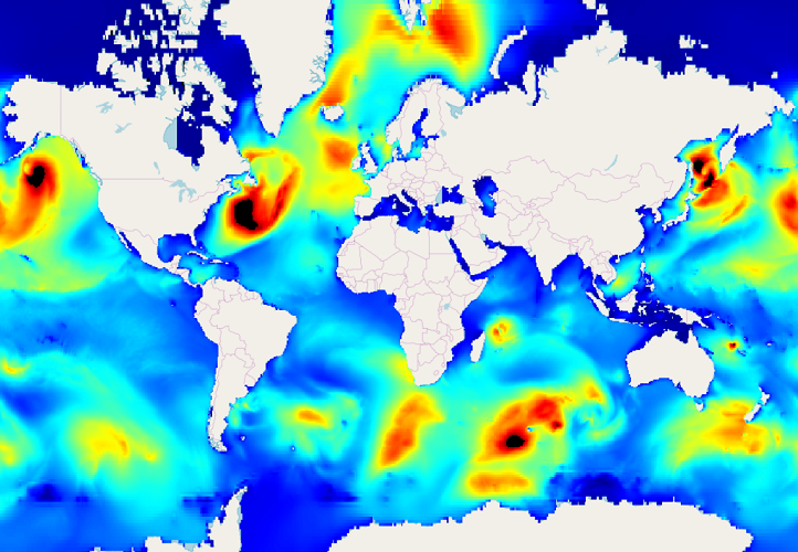
Daily air-sea heat fluxes dataset on the last 27 years (1992-2018). Global coverage with 0.25° resolution. Data is mainly coming from aggregated calibrated scatterometer datasets and numerical models. Main geophysical parameters are: sensible heat flux, latent heat flux, wind speed, SST, air temperature. Latest version : 4.1 released in June 2019.
-

SpiArcBase is a software developed for the treatment of Sediment Profile images (SPIs). Sediment Profile Images (SPIs) are widely used for benthic ecological quality assessment under various environmental stressors. The processing of the information contained in SPIs is slow and its interpretation is largely operator dependent. SpiArcBase enhances the objectivity of the information extracted from SPIs, especially for the assessment of the apparent Redox Potential Discontinuity (aRPD). This software allows the user to create and manage a database containing original SPIs and corresponding derived pieces of information. Once you have downloaded it, you can ask for help and stablish a helpdesk.
-
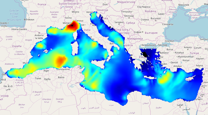
IOWAGA sea-states forecast best estimate generated by the wave model WAVEWATCH-III and forced by ECMWF winds on the Mediterranean grid from 2017 to now
-
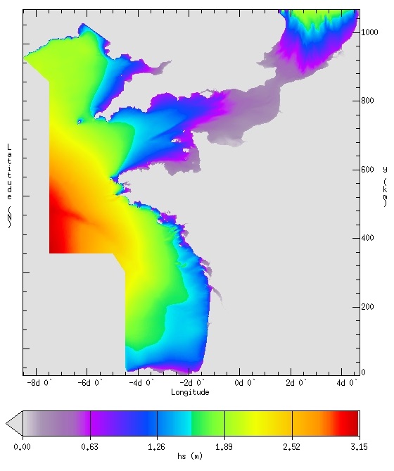
IOWAGA sea-states forecast best estimate generated by the wave model WAVEWATCH-III and forced by ECMWF winds on the French coast of the Atlantic ocean unstructured grid from 2017 to now
-
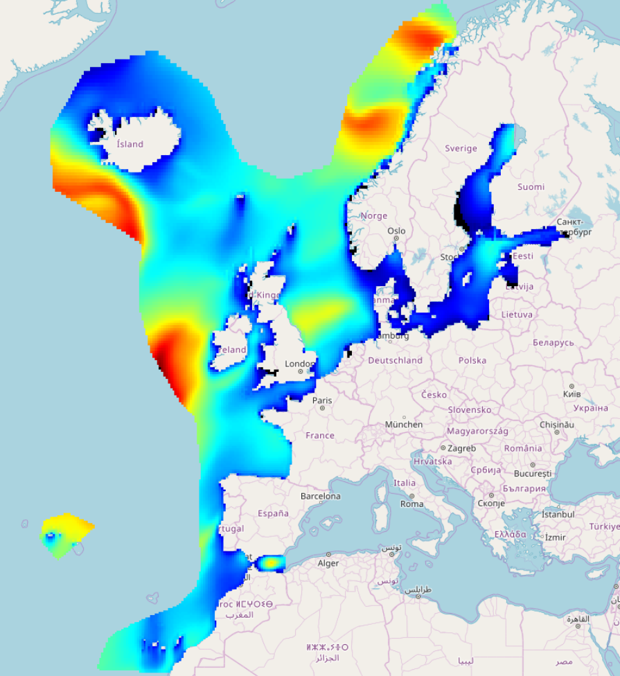
IOWAGA sea-states hindcast database generated by the wave model WAVEWATCH-III and forced by CFSR winds on the North East Atlantic grid over 1990-2012 period.
-
IOWAGA sea-states forecast best estimate generated by the wave model WAVEWATCH-III and forced by ECMWF winds on the Global grid from 2017 to now
-
IOWAGA sea-states forecast best estimate generated by the wave model WAVEWATCH-III and forced by ECMWF winds on the North mediterranean grid from 2017 to now
-
The data recorded by the oceanographic platforms operate in the Aegean and the Ionian Seas (fixed stations, ferry box system, gliders) are released through the POSEIDON portal. Physical and biochemical parameters of the marine environment as well as atmospheric parameters in the fixed station locations are available both in real time and delayed mode. The forecasting module of the POSEIDON system consists of four numerical models that provide in daily basis forecasts regarding the atmospheric, sea state, hydrodynamic and ecological conditions of the Eastern Mediterranean. The online POSEIDON database contains the data recorded by the insitu platforms offering also downloading functions for the whole data set, while a user-friendly tool is also available for accessing the results of all the forecasting models for the last five years.
-

This HF radar system is composed by two CODAR Seasonde antennas (transmit frecuency 4.525 MHz) and offers many benefits for the Basque Operational Oceanography Network such as: the improvement of the knowledge about surface currents and their forcing physical processes, marine safety, search and rescue, pollution response, validation and calibration of both hydrodynamic and pollutant drift forecasting models, data assimilation on progress, etc. The access from raw radial data to processes 2D surface current is provided for scientific and applied purposes (Coastal processes, marine safety, search and rescue, pollution response, etc).